
Polnav mobile APP
Stay ahead of the traffic with Polnav mobile’s efficient route planning and real-time updates. Never miss a beat with speed camera reminders and enjoy a smart driving experience with Apple CarPlay and Android Auto support.


Just One Click to Install The Widely Verified Navigation App
The most robust navigation system for avoiding anything that drivers dislike encountering, certified by multiple international automakers.
支援多種作業系統
Android / iOS / Linux / QNX / WinCE...
專屬語音播報
貼心的語音提示,指引道路
特 色
客製化的整合系統項目
三軸陀螺儀導航系統
客服中心整合
抬頭顯示整合
LBS 興趣點廣告平台整合
即時車流路網
即時交通路況資訊
車道偏移警示系統
 
前車碰撞警示系統
擴增實景導航
胎壓偵測系統整合
EV 電動車充電站資訊整合
EV 電動車控制器區域網路整合
語音辨識整合
雲端運算應用整合
Features
Precise and smooth offline navigation experience.
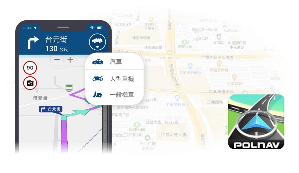
Vehicle Compatibility
Polnav supports cars, motorcycles, and scooters with mode selection based on engine displacement to plan the most suitable route, ensuring a safe and convenient driving experience. Polnav provides a safe and convenient driving experience for all users, addressing concerns such as narrow roads for car drivers and accidental entry to highways for motorcycle drivers.
Car Connectivity (Apple/ Android Auto)
Polnav mobile seamlessly integrates with both Apple CarPlay and Android Auto, allowing drivers to effortlessly access navigation tools on their vehicle’s built-in display. This integration ensures that drivers can safely navigate using offline maps and other intelligent features without distraction or the need to take their hands off the steering wheel.
Voice Input
Voice search feature designed for users who prefer faster and more convenient keyword input. With this feature, drivers no longer have to spend time slowly typing in place names, significantly reducing the danger of distracted driving.
Text-to-Speech (TTS) Guidance
Polnav’s TTS Guidance announces road, exit, and highway names, providing turn-by-turn voice instructions. Easily change text and voice prompts for different countries, with over 30 voices available. Select your preferred language and apply it for seamless navigation.
Lane Assistance
Highway Exit: Provide a comprehensive list of nearby exit ramps and rest stops, ensuring drivers do not miss any exits and reach their destination smoothly.
Switch between elevated road and surface street: This feature facilitates immediate navigation adjustments, resulting in improved directional accuracy.
Lane Marking function: Displays arrows to guide drivers to the appropriate lane for upcoming highway interchanges, improving lane positioning and reaction time.
Speed Limits and Speed Camera Alerts
Polnav Mobile’s speed alert system notifies users of their speed and speed camera locations, enabling them to adjust their driving accordingly. The system offers voice notifications when approaching a camera, along with displaying the speed limit and remaining distance, significantly reducing the likelihood of receiving a ticket.
Pop-up Junction View
While driving through a complex junction, Polnav mobile will display a pop-up view of the junction, along with clear road markings, just before the complex ramp or interchange, as you approach the highway exit or intersection.
Real-Time Traffic
Polnav offers real-time traffic data from various reliable sources, including government data, our own traffic data, and verified third-party partners. With the help of over half a million drivers, the data is frequently updated for accuracy. Polnav’s interface presents traffic events and affected roads in a clear manner, allowing users to quickly avoid and recalculate routes for efficient navigation during unexpected traffic conditions.
Real-time Parking Availability
Polnav shows real-time parking information nearby, including available parking spaces and distances, for hassle-free parking.
Highway Toll Estimate
Automated toll estimation and total distance/cost calculation for highways upon destination setting.
Keyword Search (Full Text/ Fuzzy Search)
Keyword Full Text Fuzzy Search enables easy destination search by simply entering partial names of points of interest or roads, with related terms appearing near the top of the list. Search results are sorted by distance, with a maximum searching distance of 2,000 kilometers and a list of 300 POIs previously in sequential order for future convenience. Nearby POIs can also be searched by category, such as restaurants, shopping, travel, hotels, traffic, government, sports facilities, service centers, and emergency calls, for faster destination search.