Polstar Map is built on a cloud-centric online navigation architecture. Unlike traditional navigation systems that rely primarily on locally stored data, Polstar Map performs all route planning and traffic decision-making in real time, dynamically adjusting routes based on the most up-to-date data available.


An intelligent driving navigation solution built around real-time, online navigation.
Android / iOS / Linux / QNX / WinCE...
貼心的語音提示,指引道路
客製化的整合系統項目
三軸陀螺儀導航系統
客服中心整合
抬頭顯示整合
LBS 興趣點廣告平台整合
即時車流路網
即時交通路況資訊
車道偏移警示系統
前車碰撞警示系統
擴增實景導航
胎壓偵測系統整合
EV 電動車充電站資訊整合
EV 電動車控制器區域網路整合
語音辨識整合
雲端運算應用整合
Polstar Map is an intelligent driving navigation application designed with a core focus on Taiwan’s road environment and real-world driving needs.
Built upon years of user feedback and extensive real-world driving data, Polstar Map redefines its navigation logic and user experience to address Taiwan’s unique road structures, traffic regulations, and driving behaviors. This approach enables the delivery of a safer, more responsive, and highly localized navigation service.
At its core, Polstar Map adopts an online navigation architecture, where all route planning and traffic decision-making are dynamically computed based on real-time cloud data. This ensures that navigation results can be continuously adjusted in response to current road and traffic conditions.
Polstar Map seamlessly integrates with both Apple CarPlay and Android Auto, allowing drivers to effortlessly access navigation tools on their vehicle’s built-in display. This integration ensures that drivers can safely navigate using offline maps and other intelligent features without distraction or the need to take their hands off the steering wheel.
Polstar Map supports multiple vehicle profiles, including:
Passenger vehicles
Motorcycles
Large motorcycles
Trucks and large vehicles (with configurable vehicle dimensions)
Based on the selected vehicle type, road restrictions (such as prohibited routes, height limits, width limits, and speed limits), and real-time traffic conditions, the system dynamically calculates the most appropriate routes to effectively prevent:
Passenger vehicles from entering narrow or unsuitable roads
Motorcycles from mistakenly accessing highways
Large vehicles from traveling through non-compliant or restricted routes
Polstar Map adopts a cloud-centric online navigation architecture, where route planning and traffic decision-making are dynamically updated based on continuously refreshed data.
Real-Time Route Recalculation
When road incidents such as accidents, congestion, construction, or temporary closures occur, the system can instantly recalculate alternative routes to help drivers avoid high-risk or inefficient road segments.
Multi-Source Real-Time Data Integration
Polstar Map integrates real-time traffic data from multiple verified sources, including:
Government-published traffic information
Internal traffic data repositories
Real-time user reports
Verified third-party traffic data providers
Reduced Risk of Navigation Errors
By leveraging a real-time data-driven architecture, Polstar Map effectively minimizes the risk of misrouting caused by outdated map versions, preventing drivers from being directed into modified, under-construction, or closed roads.
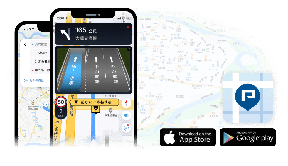
Polstar Map’s TTS Guidance announces road, exit, and highway names, providing turn-by-turn voice instructions. Easily change text and voice prompts for different countries, with over 30 voices available. Select your preferred language and apply it for seamless navigation.
Highway Ramp Exits
Lists exits and rest areas in order of proximity, from nearest to farthest
Provides information in a visual format
Helps drivers quickly understand route nodes and avoid missing exits
Polstar Map’s overspeed alert system notifies drivers of their current speed and the locations of speed cameras, enabling timely adjustments to driving speed. As drivers approach a speed camera, the system provides voice alerts while displaying the current speed limit and the remaining distance, significantly reducing the risk of traffic violations.
When navigating high-complexity road segments—such as highway ramps, elevated road entrances/exits, or multi-lane intersections—the system provides advance visual or real-scene guidance. Correct driving lanes are clearly indicated, reducing the risk of sudden lane changes and improving overall driving safety.
Within supported indoor map areas:
Tap on points of interest (POIs) to access building interiors
Support for floor switching
Browse information on stores and facilities
Applicable to complex spaces such as shopping malls, transit hubs, and other multi-functional venues.
Polstar Map provides enterprise-grade location and device management capabilities:
Once devices are linked, real-time locations can be monitored via the backend system
Supports monitoring and historical location records
Users can control whether the app transmits location data
This functionality is ideal for fleet management, logistics operations, and field personnel applications.